The Two Row Wampum (a belt sewn of two rows of purple quahog beads on a white bead background, alleged to be 400 years old) is an object of great symbolic importance to Haudenosaunee people.
The assess the very controversial story of the validity of the "Two Row Wampum" belt, and the supposed "Tawagonshi Treaty" of 1613 linked to it, we need to go back to the time when the Dutch and Mohawk first came into contact. Both items are alleged, via Haudenosaunee oral tradition, to underscore all subsequent relationships with Europeans. However, for our purposes (contemporary Canada) the only chronology that matters dates from time when the British and the Five Nations were first in contact with each other. In 1664 the British took over administration of the New Netherlands colony from the Dutch by right of conquest. The British may or may not have been aware of the purported "Two Row Wampum" agreement or treaty that was supposedly established between the Dutch and the Five Nations in 1613. The wampum, recently repatriated to the Six Nations, is known as Guswhenta (Kaswentha), that to this day is the subject of immense controversy between Natives and academic scholars.
The world outside the Haudenosaunee orbit by in large is of the opinion that the entire concept and everything to do with it (the treaty document and the wampum belt) is bogus, little more than a story that Haudenosaunee have magnified by selective interpretation. Hence it is now a convenient item that guides all relationships between them an European nations - illustrating equal but separate - in other words independent sovereign peoples. However, any document to surface that seems to support the belief that a true meeting between Mohawk and Dutch occurred in 1613 has been shown to be, or is suspected to be, a forgery. There is no clear independent validation. So in other words were are supposed to accept Haudenosaunee oral testimony, which would have to extend back 400 years, as being valid. This is asking too much. If such an important agreement was in place there should be other contemporary references to it in the copious records of the 17th to 18th Centuries. There isn't a direct reference, only oblique possible references, so we can perhaps dismiss this whole business as wishful thinking that helps to justify a key principle in Haudenosaunee thinking - sovereignty.
The most recent article to explore all of the evidence is by Jon Parmenter (2013) and can be seen here. He takes a position that the oral traditions of the Haudenosaunee should not be dismissed, particularly when there are documents that can be seen (although controversially) as supporting the beliefs that could have a footing in events distant in time. He appears to have done a reversal on an article he wrote earlier. An article by Otto in the same journal, Journal of Early American History (see here) takes a very different position, and attempts to show that the archaeological, historical and other lines of evidence do not offer sufficient backing to support the oral tradition. It is difficult to ignore the article written one year earlier (2012) by Gehring and Starna who, with William Fenton demolished the authenticity of the Tawagonshi document 25 years ago. Some of the reasons include the fact that the supposed names on the document are actually villages, not Chiefs. Thus it is difficult to see it as a "treaty" of any description even were it authentic. Gehring and Starna, experts in 17th Century Dutch language note that it is a combination of 17th and 20th Century terminology. In addition, the only copy was found under unusual circumstances, with Van Loon, who found the document at "the Mississauga Reserve" in Canada. I am assuming that this would be the New Credit Reserve, but no further information is forthcoming. Anyway, it is seen as a document of immense significance to the Haudenosaunee and is kept, supposedly, in a bank vault in Syracuse NY. Considering the credentials of these scholars in 17th Century Dutch and Iroquoian culture, their assessment (seen here) cannot be easily dismissed.
Ultimately, it really doesn't matter if the goal is to determine whether the Tawagonshi "Treaty", the Two Row Wampum, and oral tradition support Six Nations sovereignty. The answer is a resounding no. Even if the agreement is valid, and the belt is as old as it is purported to be, what happened in the Dutch regime it has no bearing on British - Haudenosaunee relationships - unless such an agreement had been "renewed". Also at best it was an "arrangement" between some of the Dutch colonists and the Mohawk, and so has no direct ties to the Dutch Crown - it is merely a local agreement. It does not appear that the successor British colonies gave the agreement any significance, and the British Crown did not acknowledge its validity, but Colonial officials may have given "lip service" to the concept, often confusing it with their legitimate Covenant Chain agreement. The actual belt his highly unlikely to date from 400 years ago (the matter is dealt with extensively in the above sources), and its content of two purple lines bordered by three white lines could mean anything - it is only tradition that gives an interpretation. Oral history depends on human memory. The Five Nations were descimated by endless wars, and the devastating effects of European diseases. By the late 1600s there were few true ethnic Mohawk (most were captives from other nations), and generations of elders who had true knowledge of earlier events were in very short supply. This combined with the reality of the way in which human memory works (e.g., the studies of Elizabeth Loftus of the University of California Irvine) shows that ove time and retelling a "memory" will be shortened, distorted, and changed in ways that reflect the times. In other words it is not a reliable source of information. Hence the need for written recordings that can be brought out and read to all, including who signed a document. A wampum belt is devoid of context and specificity and we must simply "trust" in what is being revealed by someone said to know its meaning. To romanticists this is fine, to scientists and historians the process is a set up for a well known phenomenon of "seeing what one wants one is primed to see". Memory tends to be selective, and conforms to expectations including those which are politically based.
At the Bicentennial of the Battle of Queenston Heights in October 1812, two well known Six Nations members displayed the belt to the assembled group, explaining its significance to Six Nations people. In my opinion this object with symbolic significance is being used as a justification for swaying public opinion toward the legitimacy of Six Nations "rights" bolstered by historical artifacts that should not take on mystical, spiritual features which seem to be attached to it. Here the image made of sewn white and purple wampum beads is somewhat mysterious. It purports to show, in a very primitive symbolic way, something that would not be self evident unless "interpreted" by someone who claims to know what it means. The object shows only two parallel purple lines on a white background. It is however said to illustrate or "mean" two canoes each going their way along parallel paths and not interfering with each other. Some have interpreted this as a sovereignty pact, but it was not, as far as the incoming British were concerned. The British have been very consistent over the years. Lands that come into their possession become sovereign British territory, and belong to the Crown of England. The "Two Row Wampum" may actually be conflated with the British agreement (no controversy here) known as the "Covenant Chain" of 1677 which had nothing to do with sovereignty, but rather a military alliance.
The concept that the British wished to instill was a relationship involving the "Covenant Chain", where the British and the Five Nations were bound together by a metal chain with links that needed to be "brightened" every so often, generally by offering bribes to Five Nations Chiefs, which the latter readily accepted. There was never any disagreement about the Covenant Chain, although it was "broken" for a short time in 1753 by Mohawk Chief Hendrick Peters Thoyanoguen. It did not last because it meant that the presents stopped coming and the other Chiefs became annoyed by Hendrick and the Covenant Chain was renewed in the 1750s. Again, there was no illusion of sovereignty, the King was the Sovereign to all of the people of the Colonies, including His Majesties Indian subjects. There was no disagreement here either, the King was always termed "our Sovereign Lord" or "Great Father" or something of that nature. The alliance held firm, at least with the Mohawk, through the Revolutionary War.
What is key to note is that these concepts have been used even in modern times to allude to the "fact" that the Six Nations are a people allied to, but independent of, the British Crown (later the Federal Government of Canada).
Six Nations has requested (required) the return of various wampum belts that over the years had been given (e.g., by Pauline Johnson) to museums, anthropologists, collectors and so on. Supposedly they are now where they should be, according to the Great Law of the Confederacy, with the Firekeeper of the Onondaga Nation whose role it is to keep these records of treaties, agreements, Chiefly titles, etc. so that they can be presented as the occasion requires. The problem is that a wampum belt is made of white or purple beads strung together to make pictograms. Hence they tend to be schematic, much more than say the Bayeux Tapestry which records in detail the events leading up to the Norman Conquest of England in 1066, and the Battle itself. This record is woven with thread where characters can easily be recognised and even the type of battle armour recognised from this document - such is the attention to detail. Wampum belts do no have this aspect, they are used to trigger the memories of those who have participated in a particular event, or who have been told via oral history of the meaning of the belt. Clearly any scientist studying memory would chime in and present the research based (factually derived) data on the fallibility of human memory - just think of the popular "telephone game". If there is a disconnect, such as the time that the wampum belts were outside the possession of the Six Nations, then somehow this gap must be filled in other ways. Likely this will be from the writings of anthropologists, often affiliated with the Smithsonian Institute, who have studied the subject. So as a key document that can provide what the English speaking world has in the Magna Carta, the Two Row Wampum has more symbolic and sentimental value, and they are also historically significant if they date back to say the 17th Century.
However when carefully exploring all the records of the time there is a huge inconsistency that is clearly evident. It is difficult to reconcile the belief that the Two Row Wampum reigns to this day with facts such as the statement of the (then) Five Nations during the Nanfan Treaty. Here in 1701 they conveyed their beaver hunting grounds over to, our great Lord and Master the King of England. It appears in the strongest terms to imply a subjugation to the Crown. This perspective is pervasive in the records, where the King is referred to as, our great Father. In the Proclamation of 1763, in no uncertain terms, the British authorities claimed "dominion" over their aboriginal "subjects" and their lands - which must be surrendered to the Crown for a valid sale to occur. None of this in any way sounds like a relationship between equals. And yet, in document after document, the Six Nations are referred to as "allies" of the Crown. How does one make sense of the inconsistencies?
While at one time I was a true Liberal and liberal through and through, the events of Caledonia in 2006 showed me that it is the liberal political correctness and caving in to various myths about First Nations people (despite my own genealogy, which needs to be shelved until we can establish wherein lies the truth), and the burden of guilt White people are or should be carrying around that forced me to challenge these assumptions. It is all a big lie, and has for years been perpetuated by the left - leaning media (I used to tilt in that direction too). So now it is time to explore how the more right - leaning, conservative Canadians view the situation. We can start with the Two Row Wampum myths - as one can see here in a Sun News article. I never would have believed that there would come a day when I would actually agree with anything coming from that source - I used to simply ignore it. No longer.
It is evident that after the move to the Grand River in 1784, the Six Nations and the British authorities (e.g., Governor Simcoe) had diametrically opposed views on what the Haldimand Proclamation meant in terms of the ability of the former to do with the land as they pleased. However by 1835, the Six Nations had agreed to surrender the lands to the Crown who would sell or lease them, and the latter would return the monies to the Six Nations (either directly or through trusts typically involving bad investments - which tended to become very controversial when things went sour).
The Six Nations have assumed the legitimacy of the sovereignty issue, and as an example of how this plays out, one would be hard pressed to find a Canadian flag flying at a private residence on the Reserve, but instead the Confederacy flag flies everywhere, being particularly prominent at the establishments selling cigarettes. If a Canadian flag is placed on any disputed territory it will be summarily removed and often destroyed. The Ontario Provincial Police are "unwelcome" at Six Nations, and instead policing is accomplished by an OPP trained Six Nations police force. Much more will be said on this subject in a later post.
Once again it matters not what the weight of evidence or facts say, the belief is that the Two Row Wampum (the actual belt being in the possession of Six Nations leaders) "proves" that the Six Nations are a sovereign people, allied to, but not ruled by, Canada. One might ask though, that since there is no aboriginal connection to the land in the Haldimand Tract (the Six Nations are aboriginal to the United States), does this "status" justify the approximately 32 million dollars of Canadian taxpayers monies from Indian and Northern Affairs Canada that flows into the Six Nations Reserve each and every year. It only gets more tangled if one examines other "rights and entitlements" that Six Nations members receive. This will be the subject of a later post.
Updated: 20 - 21 January 2014.
DeYo.
Saturday 2 November 2013
The Nanfan "Treaty" of 1701 Does NOT Give Six Nations People Special Hunting, Fishing and Consultation Rights in Ontario
If one believes in the maxim that one cannot give away or sell that which does not belong to you, then the provisions of the treaty negotiated between Governor John Nanfan and the Six Nations in 1701 can have no validity - despite beliefs to the contrary. The principle is enshrined in law under the term, Nemo dat quod non habet. See here for details. This principle is derived from English Common Law and is expressed succinctly here.
What is indisputable is that during the 1640s, the Six Nations (largely Seneca and Mohawk) conducted a war of utter destruction whereby the Native peoples living in Ontario were largely wiped out, and the few survivors were dispersed or adopted into the families of the victors. Thus the Huron, Petun, and Attiwanderonk (Neutral) peoples ceased to exist and Southern Ontario was "cleared" of human occupants leaving the area as a hunting ground for the Six Nations. Later Six Nations communities were established north of Lake Ontario and by 1687 there were 7 settlements established between Kingston and Hamilton. By the year 1700 all were destroyed or abandoned as the Six Nations retreated back to their traditional homeland. They were driven out by an alliance of their traditional enemies including the Ottawa, Potawatomis, and various Ojibway groups including primarily the Missisauga. The most comprehensive consideration of the wars of this era can be found in a 474 page book written by an author who attempted to explore the mobility and information gathering prowess of the Iroquois in the period of 1534 to 1701. See, Jon Parmenter, The Edge of the Woods, Michigan State University, East Lansing, 2010.
It is therefore somewhat puzzling that in the year 1701 the Six Nations decided to cede their beaver hunting grounds in Southern Ontario to the Crown. Here 20 Chiefs of the Six (then Five) Nations put their marks to what became known as the Nanfan Treaty. Here they, surrender, deliver up and forever quit claim the lands in Southern Ontario, which the Five Nations claimed to have conquered, to our great Lord and Master the King of England. The Five Nations asked only to be allowed to continue to hunt on the land in perpetuity.
Since the Missisauga owned these lands by right of conquest, the Five (Six) Nations had no right to be making a treaty relating to property which they did not in any form own in 1701. It is truly odd that even to this day, this Treaty is cited by many (who need to do more in depth research on the subject) as a justification of claimed rights by Six Nations to unregulated hunting and fishing in Southern Ontario. However the facts are clear, and despite the strong beliefs as to rights and entitlements here, the Nanfan Treaty is invalid and cannot be used as justification of any fishing and hunting privileges outside those enjoyed by the general citizens of Ontario.
The Six Nations are now using "treaty rights" to justify coercing power company owners building wind turbine projects in Southwestern Ontario (e.g., Port Ryerse) to "consult" and then to "negotiate" - meaning give a few million dollars to either the Elected or Confederacy Councils or other pressure groups. This is money that is in the category of "ill gotten gains". If these companies have such a generous spirit that for no reason they wish to turn over a large percentage of the profits to Six Nations, that is their choice. The point is that there is nothing based on "treaty rights" which would justify any interference by Six Nations with activities going on outside the bounds of the present day Reserve.
Prior to the establishment of this blog, Garry Horsnell provided an excellent overview of the subject as seen here. There is an excellent three part series on the Nanfan Treaty by those whose primary interest is the Dundas Valley (which has been impacted by the Six Nations invoking the Nanfan Treaty to assert rights to bowhunt in the Valley). Note particularly the copies of the original Nanfan Treaty (front and back of same) which may be the first time it has been seen outside of storage in Kew, London in a couple of hundred years. The research is exemplary and the articles well worth studying. See here, and remember to click on parts 1 and 2 also.
The Nanfan Treaty also directly addresses the matter of perceived Six Nations sovereignty - one of the most contentious of issues. This will be the subject of the next post.
Update: Please see here for a more detailed and current discussion of this topic. 20 January 2014.
DeYo.
The Six Nations are NOT Aboriginal to the Haldimand Tract
One of the largest misconceptions, and one that is almost universally believed, is that Six Nations people are Natives or aboriginal to the land granted by Governor Haldimand in 1784. The facts, however, do not support this belief.
It comes to mind that if it were Six Nations land, why did they not just move on to their property and assume all the rights of owners in fee simple (exclusive ownership). The reason is that they were dispossessed Loyalist refugees looking for a suitable place to settle. When Captain Joseph Brant chose the Grand River lands, it was necessary for the Crown to purchase the lands from the rightful owners - the Missisauga. It was widely known that the only claimants to these lands at that time were the Missisauga. When Lt. John Young of the Six Nations Indian Department and his Mohawk wife wished to establish a farm on the Grand River (before the choice of lands had been made by Brant and others), he negotiated a deal with the Missisaugas and purchased a plot of land one mile by one mile along the Grand River near Cayuga. Young was well aware that for the deed to be recognized as valid by all parties, only the rightful owners could negotiate the transaction. He did not hesitate to approach the head chief of the Missisauga.
When Governor Haldimand was faced with the task of accommodating the thousands of Six Nations and other Native peoples who had fought for the Crown, and whose aboriginal properties in NY had been utterly destroyed by the depredations of American General Sullivan, he obtained a deed of sale from the Missisauga who owned the entire region by right of conquest dating to the closing years of the 1600s. True aboriginal peoples of the region, including the Missisauga and Ojibway, sold outright all of their interest in their former lands with the exception of parcels that they wished to be reserved for their own use. Thus there was no wiggle room for contesting over this or that parcel of land, what was sold became Crown land and it was the right of the Crown to sell or otherwise dispose of these acquired lands in any way it saw fit.
We constantly hear of Six Nations claiming to be Natives (all others are non-Natives, or placed under other categories such as "settlers"). In fact the Six Nations are aboriginal to the area between the mouth of the Mohawk River to the Finger Lakes and beyond towards Lake Erie. However these lands do not belong to the Crown any longer, and so the Six Nations are no more aboriginal to the Haldimand Tract than their fellow Loyalists and military comrades, the Young, Nelles, Huff and Dochstader families who are of German descent. Often one hears that aboriginal rights evolve from the early treaties signed when New York was a possession of the Crown, or by conquest after destroying and dispersing the Huron and others in what is today Southern Ontario. In fact this belief is wrong. Historians do not debate the point - the Six Nations had no valid claim to any lands that belonged to the Missisauga, and purchased by the Crown. So who are the true Natives, aboriginal people, of the Grand River Tract? The Missisauga, and only the Missisauga.

Knowing that in fact, the Grand River Tract is not Aboriginal, Native land to anyone at Six Nations, makes the above sign, posted by the Six Nations at Caledonia, something of an enigma. If the Mississauga had erected it - there is an element of historical truth.
The matter has been misunderstood largely because of the Nanfan Treaty of 1701, which will be the subject of the next blog posting.
DeYo.
It comes to mind that if it were Six Nations land, why did they not just move on to their property and assume all the rights of owners in fee simple (exclusive ownership). The reason is that they were dispossessed Loyalist refugees looking for a suitable place to settle. When Captain Joseph Brant chose the Grand River lands, it was necessary for the Crown to purchase the lands from the rightful owners - the Missisauga. It was widely known that the only claimants to these lands at that time were the Missisauga. When Lt. John Young of the Six Nations Indian Department and his Mohawk wife wished to establish a farm on the Grand River (before the choice of lands had been made by Brant and others), he negotiated a deal with the Missisaugas and purchased a plot of land one mile by one mile along the Grand River near Cayuga. Young was well aware that for the deed to be recognized as valid by all parties, only the rightful owners could negotiate the transaction. He did not hesitate to approach the head chief of the Missisauga.
When Governor Haldimand was faced with the task of accommodating the thousands of Six Nations and other Native peoples who had fought for the Crown, and whose aboriginal properties in NY had been utterly destroyed by the depredations of American General Sullivan, he obtained a deed of sale from the Missisauga who owned the entire region by right of conquest dating to the closing years of the 1600s. True aboriginal peoples of the region, including the Missisauga and Ojibway, sold outright all of their interest in their former lands with the exception of parcels that they wished to be reserved for their own use. Thus there was no wiggle room for contesting over this or that parcel of land, what was sold became Crown land and it was the right of the Crown to sell or otherwise dispose of these acquired lands in any way it saw fit.
We constantly hear of Six Nations claiming to be Natives (all others are non-Natives, or placed under other categories such as "settlers"). In fact the Six Nations are aboriginal to the area between the mouth of the Mohawk River to the Finger Lakes and beyond towards Lake Erie. However these lands do not belong to the Crown any longer, and so the Six Nations are no more aboriginal to the Haldimand Tract than their fellow Loyalists and military comrades, the Young, Nelles, Huff and Dochstader families who are of German descent. Often one hears that aboriginal rights evolve from the early treaties signed when New York was a possession of the Crown, or by conquest after destroying and dispersing the Huron and others in what is today Southern Ontario. In fact this belief is wrong. Historians do not debate the point - the Six Nations had no valid claim to any lands that belonged to the Missisauga, and purchased by the Crown. So who are the true Natives, aboriginal people, of the Grand River Tract? The Missisauga, and only the Missisauga.
Knowing that in fact, the Grand River Tract is not Aboriginal, Native land to anyone at Six Nations, makes the above sign, posted by the Six Nations at Caledonia, something of an enigma. If the Mississauga had erected it - there is an element of historical truth.
The matter has been misunderstood largely because of the Nanfan Treaty of 1701, which will be the subject of the next blog posting.
DeYo.
A Deed is NOT Invalid Because it Wasn't Signed by all 50 Chiefs
There is a belief that for a deed or similar document to be valid, it must include the signatures of all 50 Chiefs of the Six Nations. For example, see here for the Six Nations Land and Resources Department website, where this position is expressed in their pamphlet, Land Rights: A Global Solution for the Six Nations of the Grand River. Here they question whether all 50 Chiefs were present at a Council where a particular land matter was discussed, and whether those present understood what was being said or read to them. The fact that there was never a requirement that 50 Chiefs be present at any Council meeting or at the signing of any document in the past does not seem to be acknowledged in this document. Furthermore, by the 1840s many of the Chiefs spoke or understood English, and they would be in a position to explain matters to any who had questions. Besides, there were always Government interpreters present. So basically, nothing could be further from the truth, but beliefs can be "sticky" even when faced with insurmountable evidence to the contrary.
Six Nations Territory, New York, Founding of the League to 1779: First, things are seldom as clear as people wish them to be. Even before the League of the Iroquois (Six Nations Confederacy) council fire was extinguished at Onondaga during the Revolutionary War, there was disagreement as to whether for example the Onondaga should have 13 or 14 chiefs, and whether the League itself had 49 or 50 chiefs.
What was important in the early days was to ensure that, if possible, there were signors from all of the major clans - a practise that extends far back into the 17th Century in Mohawk Country in what is today New York State. The Mohawks had three clans, the Turtle, Wolf and Bear, and three families within each clan. After examining most if not all of the deeds relating to Mohawk land in NY, I can report that never was there an instance where all 9 Chiefs signed any deed. The only time that all of the Mohawk Chiefs can be seen on a single document (and merely as a record of who was present) were at large multi-Nation conferences such as that in Albany in 1754; and on lists of those who participated in a particularly important battle or military campaign - such as those who went with Sir William Johnson to Montreal in 1760.
The "Nanfan Treaty" of 1701 includes the totems (clan symbols) of six Mohawks - not the 9 League Confederacy Chiefs. Not only that, but the composition of those authorized to sign a document of this nature included all those of "consequence", not just the Confederacy Chiefs. The Nanfan document states that, wee the Sachims Chief men, Captns and representatives of the Five nations ....... Chief men would include village chiefs, and Captains were war chiefs. Thus it is insupportable to suggest that only documents including the signatures of all 50 hereditary chiefs are legitimate. That was in fact simply not the case.
On deeds, the composition of signors was often irregular to say the least - yet these deeds were only challenged if it could be shown that the Mohawk had been cheated out of the land. For example the unscrupulous White man George Klock had located Mohawk men with no authority to sign deeds, and plied them with alcohol such that they were willing to put their marks on a document granting land to Klock. These deeds were indeed challenged by the Mohawk, and Sir William Johnson or other Crown representative attempted to have them annulled. Some deeds that stood the test of time, such as the that for the Timmerman property near St. Johnsville NY, even when signed by what might be considered an "unusual assortment" of individuals. In 1732 two Mohawk men and a Mohawk woman each put their clan sign to the paper. All three clans were represented. The property is still in the hands of Timmerman descendants to this day. No one challenged the paperwork for any reason whatsoever.
So local tribes / nations made their own deals with the White settlers, and the deeds were later confirmed by the Crown. Not only tribes / nations, but even villages made independent deals with Whites. For example, the Lower Mohawk of Tiononderoge (Ft. Hunter) signed land transactions that did not include any representatives from their kin at the upper village. Similarly the Upper Mohawk of Canajoharie made arrangements to sell land but there are no signatures or marks of any resident of the Lower Mohawk village located 20 miles down the Mohawk River.
Lets be clear about this, the belief that it has always been the case that all 50 Chiefs were required to sign any document that was to be considered legal is false, it was never true, except perhaps in the ideal, but NEVER in practise. In fact, the Six Nations in New York, as a group, generally only signed documents under the auspices of the Colonial officials at New York, Albany, or Philadelphia - and there was no guarantee as to who would and would not show up - or be delayed for weeks. As long as what might be considered a "quorum" appeared, it was a go - and was not challenged later by the Six Nations.
It must be emphasised that in examining any document signed by the Chiefs in Council, there will be some whose signatures appear on almost every occasion until their death, and others who appear to have been much less diligent in attending, and their names appear sporadically. It is important to note that since about 1720, the Tuscarora have been accepted as members of the Confederacy (changing the Five Nations to the Six Nations). However they were not "fully incorporated" members, and were typically only allotted one to two "unofficial" chiefs to council. Also, if one takes the time to examine the names of each and every individual present at a council meeting, at a treaty, or at a signing of a surrender, there are typically a very heterogeneous group in attendance. For example the Treaty of Fort Stanwix (1768), was attended by Sir William Johnson and 3008 Indians, the Six Nations - Shawanese, & Delawares, Senecas of Ohio & dependts. At this treaty there was some notables not present. The 6 chiefs who had died about this time were condoled here. Sir William gave 6 Black Belts (wampum) to "Cover the Graves of the Six following Chiefs viz - including one Mohawk, Oneida, Cayuga, Seneca, Shawanese, and Delaware (Sir William Johnson Papers, Vol. 12, p. 629). The treaty was not considered invalid because some of the chiefs had died and had yet to be replaced. Anyone who would assert that all 50 League chiefs should magically be in one place at one time, or anything done at the conference or treaty or other event was invalidated, simply has not read the history.
Six Nations Territory, Grand River Ontario, 1785 to Present: Once the Six Nations and allied tribes arrived at the Grand River, signatures were only valid if they were signed at one of the council meetings which took place in the years 1785 to about 1805 occasionally at the Indian Council House near Ft. George, Niagara, but more commonly at the Mohawk Village in what is today Brantford. From about 1805 onwards, most of the Council work took place at the Onondaga Longhouse near what is today Middleport (until the Council House was built at Ohsweken some years after the move to the consolidated Reserve in 1847). Thus the document only had to be signed by the Chiefs who attended Council on the day the item was presented for discussion. I have seen deeds from the early 19th Century with only a half dozen signatures, and others from the mid 19th Century with 40 or more.
There were occasions when it was more important to have the signature of every available head woman, plus principal warriors and chiefs. An example is the deed signed by the Mohawks of the Lower Village (Fort Hunter, Tiononderoge) and one signed by the Mohawks of the Upper Village (Canajoharie) at the Indian Council House in Niagara in July 1789. By these instruments they signed away all rights to their former property in the State of New York via their negotiator Jelles Fonda (references available upon request). A later document to the same effect was signed by the head chiefs of these villages, John Deserontyon and Joseph Brant Thayendinagea, in 1797. As a result, the Mohawks of Tyendinaga and Six Nations have no claim to any lands in the State of New York, despite this being their aboriginal homeland - these points no one could or should contest.
Even the task of a researcher deciding the status of someone signing any particular document could be problematic. It appears that until about 1812, some of the Hereditary Confederacy Chiefs were "prohibited" from signing their Chiefly names to documents (which would have been something of a "profanity"), although others such as Tekarihogen and Ayonwagtha of the Mohawks were seen on the earliest documents at Six Nations. Thus many used their "everyday" names, those that they had used before accepting the horns of office. Sometimes it is unclear as to whether a Chief was actually a Hereditary Chief or a Pine Tree (merit based) Chief. Both, as well as "principal warriors", signed documents. After the deeds of 1789 noted above, only the names of men appear on deeds or are listed in Council Minutes. One of the most "prolific signors" prior to 1812 was Delaware Aaron, who was not a member of the Five or Six Nations Iroquois, but was certainly a prominent member of the Six Nations Community. His signature was never considered as being anything but legitimate based on his local status.
Those who would try to impose the "Roll Call of Chiefs" as seen in publications such as Fenton (1950, pp. 59-67) on the Six Nations of the Grand River need to study the records pertaining to those who settled here after 1785. If they do they would quickly realise that it would be a Procrustean fit, that would not work if only because there were always "vacancies" (some at Six Nations were permanent) and other "issues". When the Six Nations refugees arrived at the Grand River in 1785, most of the Oneida, Tuscarora, and Seneca stayed back in New York. I can find no record that indicates that the 50 Chiefs of the 5 Nations were ever assembled here at the Grand River. As in the pre - Revolutionary War days, the Tuscarora, many of whom remained in New York, were never given an "official" chiefship, but those here were allowed to send one or more members to Council as a Chief. The most serious problem in terms of re-constituting the League in Canada was the paucity of Seneca. The majority chose to remain in New York. In 1785 they were consigned to one village, near the mouth of the Grand River, and could muster no more than 78 souls - about the same number as the Tutelos (who were a remnant tribe attached to the Nanticokes and Upper Cayugas), and paling relative to the number of for example Onondaga at 245 and the Mohawk at 464 (Johnston, 1964, p. 52).
A snapshot of how many chiefships were represented in Canada can be found in the work of Chadwick who included all of the names of Chiefs then installed at Six Nations, their assistant or "second chief", as well as Pine Tree Chiefs associated with the title, in the late 1890s. For example, using Fenton's listing, Seneca titles 45, 46, and 48 were "extinct" in Canada. The Onondaga's were better represented, with only numbers 23 and 31 "extinct". There were three Tuscarora titles still active in Canada, and each sent a Chief to Council. In addition there were two Nanticoke and one Delaware (Chadwick, 1897, see here). As the 19th Century was drawing to a close, some at Six Nations became very concerned that the ancient traditional system was in disarray and much was in the process of being lost. Hence Seth Newhouse (Mohawk) researched and wrote a treatise on the Constitution of the League, and even included all of the warrior's and women's names associated with each existing chiefship. He finished this work and submitted it to Council for approval in 1885 (Library and Archives Canada, MG19, F26). This monumental effort was not accepted by Council, who in turn commissioned their own version. The fruits of this request was the study of Chief John A. Gibson (Seneca) who placed the manuscript before Council in 1900, where it was approved, and subsequently published by Duncan C. Scott in 1912.
The land transactions at the Grand River, ultimately accepted by the Chiefs in Council, have yielded the most misinformation and led to the most acrimony to the date of writing this blog post - the stakes are so high. When the Six Nations first moved to the Crown land on the Grand River there was a period of time when they were only allowed to lease their lands, since the Haldimand Proclamation was not a deed in fee simple to the Six Nations, and any sales had to be approved by the Crown. Hence in 1787 many of the Mohawk Chiefs (some hereditary, some village or Pine Tree Chiefs) and a scattering of those who resided near the Mohawk Village (Auquaga Oneidas, Upper Cayugas and Delaware Aaron's people) penned their names or marks to sundry deeds which were initially 999 year leases. As time went on, most standard "bargain and sale" transactions were permitted by the Crown. Initially, large blocks of land were sold by Chief Joseph Brant (who from 1796 had "power of attorney" from the Six Nations to make such sales). Thus, for example, the Nichol Block at the northern most end of the Tract was sold. A series of "Brant Leases" for 999 years continued to be made, until such time as the lease was converted to a deed in fee simple. The typical procedure was for a Six Nations member to claim a specific piece of property on which he had made improvements (many of these plots are shown in survey maps of the time), sell it to a white man for what was considered to be a fair price, then the deed would be ratified by the Six Nations Chiefs in Council (whomever happened to be there that day), with a copy going to the purchaser, and a copy made by staff of the Indian Department and registered within their system and a Crown deed issued. This process went on at an accelerated pace throughout the 1830s and 1840s (see Johnston, 1964 for examples of these transactions).
I will focus here on the 1840s, since this was the time when the last major surrenders of land were made by the Six Nations in Council. While the "Great Law" of the Six Nations may have specified the number of hereditary chiefs assigned to each tribe, some chiefships stayed in the U.S.A., and even at the Grand River it was common for a seat to remain vacant for a long time (e.g., 3 years) after a Chief died, and there was great difficulty in finding a suitable candidate to install in the chiefly position (see Shimony, 1961, pp. 104-117 for the situation to that time). I have seen only one document that quite by chance included the "magic" number 50. On 18 February 1846, 50 Chiefs were assembled for the purpose of hammering out a land surrender agreement that included all land parcels except the consolidated Reserve (including 200 acres near the Mohawk Institute) to be retained for the Six Nations. Those Six Nations members already in possession of lands within the Grand River Tract outside the boundaries of the agreed upon Reserve could retain or sell their property and move at any time to the new Reserve. An inspection of the tribal composition of these individuals shows that there were 14 Upper and Lower Mohawks (more than the 9 described in the Great Law), and 6 Onondaga (fewer than the prescribed number). It is also important to note that there were present 4 Delawares and 2 Nanticoke among the Chiefs. These were not members of the traditional Five or Six Nations, but rather were Community members by virtue of their having moved with the Iroquoian Six Nations at the time of the American Revolution. People at Six Nations are registered as members of the Delaware band to this day, and are no less members of the Six Nations Community due to their Algonquian (Anishinabe) roots. Five days after the above Council meeting, the next gathering mustered only 47 Chiefs.
There were typically Pine Tree chiefs, Hereditary Chiefs, principal warriors and sundry others in any list of "chiefs", including the period of the 1840s. No one ever questioned this arrangement as being illegitimate at all ever - only recently when it has been convenient to look back at what was done 160 years ago and criticise what was, with a "what should have been". This is a gross insult to the Chiefs who had adapted to the changing situation at Six Nations. When some St. Regis Onondaga came to Six Nations about 1840 they were given a chiefly seat. In addition to the Delaware, until 1924 the Tutelo and Nanticoke (related to the Delaware) continued to be given chiefly council seats. The magical number 50 plus or minus zero makes absolutely no sense in terms of the realities of what was found at Six Nations from 1785 to 1924.
The "Holmes Report" (Joan Holmes & Associates) addresses the matter of the ever changing number of Chiefs present at Council meetings in her comprehensive study of Six Nations land surrenders seen here. Part 1 provides all the documentation underpinning the various surrenders from 1841 to 1848, which resulted in the present day Six Nations Reserve. All of the earlier requests to include lands such as the Johnson Settlement and the Burtch Tract in the Reserve were rescinded by the Six Nations Chiefs in Council by 1848. In Part 2, Supplemental Report, dated February 2, 2009, Joan Holmes includes a 7 page chart showing the list of names of the Chiefs present at each of 7 meetings between 1841 and 1846. This part of her work was included as a "response to the Holmes Report" by Professor Darlene Johnston, who maintained that, various Tracts were not surrendered between October 1843 and 1867. Presumably, Johnston had questioned the fact that the entire compliment of 50 Confederacy Chiefs were not at each of the various pertinent events (e.g., Council Meetings).
It is equally difficult to understand how some Six Nations can claim that for example Caledonia was never ceded, and to this day believe that it still belongs to the Six Nations. That is patently false since the lands were sold by the individual Six Nations claimants (in this case the Barefoot Onondaga Crawford family), usually to Whites (their right was never challenged by the Six Nations), and the deed was ratified by the Chiefs in Council (traditional and legal representatives of all their people) in the standard manner, and accepted by both the Six Nations and the Indian Department (the latter representing the Crown) as being entirely legal and binding. There was at the time no great dispute when between the years 1841 and 1848, the Chiefs in Council ratified the surrender of all lands not reserved for their own use by the latter date. Any lands outside these boundaries which were in possession of individual Six Nations were left in their possession, to be sold at their discretion. It was all very clear, and all were accepting of the agreement in 1850 when Lord Elgin signed a description of the specific reserved lands to be placed on record in the Indian Land Registry system.
No person or group came forward at the time to challenge the binding decisions of the combined Hereditary and Pine Tree Chiefs. The wording of all of these deeds was carefully chosen so that someone could not, or rather should not, emerge at a later date and challenge the decision of the Chiefs. Hence coming back over 150 years later and scratching around for a way to lay claim to for example the lands on which Caledonia rests is disingenuous, and as such, attempts to circumvent what the ancestors believed to be just and fair at the time. Much more on the particulars of this subject will appear in later blog posts - this point will be repeated since it is perhaps the most important factor underlying the recent efforts to "recover" land that were in fact sold long ago. There is a term or expression, reflecting racial stereotyping, that could be mentioned at this time. One wonders where the expression, "Indian giver" came from, and whether some White people may decide to press it into service in the present conflict.
What is of utmost importance is to understand the will of those Chiefs who signed the deeds to the year 1848. The wording of the deeds clearly spells out their intent. For example a typical phrasing from the 1780s is seen the what was known as the "Mohawk Deed" signed in 1787 by 9 Mohawk Chiefs (not all hereditary Confederacy Chiefs though), and 13 other Chiefs of other Six Nations members and others (e.g., Delaware) who resided on the Haldimand Tract. This deed, to members of the Nelles, Young, Huff and Dochstader families, concluded with a statement that, This being done and concluded by us the Five Nations and our Nephews the Delaware, let never our Grand Children or any whomsoever attempt to undo what we have done the same with due consideration (Johnston, p. 71). The language and intent could not be clearer. Since at least half of the Mohawks spoke English fluently, there can be no claim that, "well they did not understand what they were signing". That would be an insult to the ancestors.
In conclusion, the recent "demand" that deeds have 50 Chiefs as signors can now been seen as specious, and merely a convenient tool to confuse those unfamiliar with the history of the Six Nations and the Haldimand Tract.
Updated: 16, 22, 23 December 2013.
DeYo.
Disabling the Negotiation Process - The Theft and Hoarding of Key Documents
It goes without saying that bargaining must be done in good faith, or the whole process is pointless. Fairness dictates that in exploring relevant data, all records that could be useful must be shared with all parties. If this is not the case, one side will be handicapped to the point where the negotiations may falter, or one side may capitulate because it is assumed that the records were lost or misplaced. Without a doubt, with a collection as vast as the RG10 (Indian Affairs) collection at the National Archives in Ottawa, some important records that may show up in a catalogue, simply cannot be found. This is true at every level of government, and every record collection which spans 200 or more years. For example an index of War of 1812 claims show that John Doe made a claim numbered 342. For whatever reason there is a gap in the set of records such that claim 342 is not where it should be, and was probably lost, perhaps when the records were transferred from Great Britain to Canada - who knows.
While the above is just part of the frustration of doing comprehensive research, there are instances where records are missing and the reason is far more nefarious. They are missing because they were removed illegally. One reason may be that the a signature on a document is valuable and someone gives in to greed. Another reason could be that by removing a set of records in a matter being litigated, one side gains an advantage over the other. If the latter is shown to be true then the group that removed the records is standing in the way of a fair and just solution to the problem.
I have heard rumours of a number of instances of records relating to land claims that have vanished, and there is no clear evidence as to who the culprit is - just suspicions. This is, however, hearsay. What counts is personal knowledge, preferably gained through observation and "being there". I have direct knowledge of two instances where the record removal may have a significant impact on the land claims negotiation process. Unfortunately there was no camera or security device to offer the kind of "hard evidence" that is thoroughly persuasive. What I am left with is my memory of events - and over the years some distortions could have crept in. However, I maintain that the essentials are factual, and can be relied upon as essentially reliable and valid.
The first matter happened about 1985. Back in the day I was in contact with people who lived on Six Nations, and others who resided in rural Brant and Haldimand Counties, all interested in local history and genealogy. One day a respected local historian known to all heritage minded people, Mrs. H.H., came to visit at my home. She revealed that she had a terminal disease and had only a few months to live. Then she stated that she had made, "the biggest mistake of my life". Apparently when she learned that some key records that would be of interest to local genealogists were about to be removed from the Indian Office in the Federal Building in Brantford, she made a case that the records should remain locally so that they could be consulted by residents not able to make the journey to the Archives in Ottawa.
The Indian Office was mandated to send all of the early records, those not in active use, to Ottawa. The Federal Government is or was the custodian of said documents, and had an active microfilming programme to preserve the records for posterity. In this case the local agency relented while the matter was explored further. However, apparently in the meanwhile someone at the Band Council got wind of the business and an order went out to seize the records and bring them to the Reserve. That is all that Mrs. H.H. knew about the matter - but she was overcome with guilt as she felt that the records would never again see the light of day, at least would not be available to local researchers. Sad, very sad. She passed away a few months later, I am sure with the matter still troubling her.
There was a time when I was a familiar fixture at the Woodland Cultural - Educational Centre in Brantford. The library and hanging files, which were all open to me, contained a wealth of information about my family. By chance one day I looked at a table in the library - research room and saw piled up some bound documents which appeared to be in the process of microfilming. The name of the Indian Office, Department of Indian Affairs, Brantford was on the binding. I did not say anything, sensing that it was none of my business - but the matter disturbed me - especially in light of what my friend had told me. At a later date I petitioned the Band Council for permission to view these records for genealogical research purposes. I was turned down on both occasions. However, I was informed that if I made a request to the Research Office, they may be able to assist for a fee. Indeed this was the case. I asked for records from the 1870s, records that were likely at one time housed in the Indian Office, to be searched for certain names that were of interest. When I received the bill, I was astounded. It was a one page report with two bits of information. Never before had I paid even a small fraction of this bill, even for much more complex requests which included photocopies and photographs and even colour negatives.
While I cannot provide much more than the above - there are those at Six Nations who will also know the truth of the matter.
A small test might be in order. I know that Mrs. H.H. had explored every page of the Seneca Township Land Inspection Returns of 1845. She had made copious notes and was able to give me the exact wording from the original record. When I went to Ottawa to find the Seneca records they were nowhere to be found. However the comparable Oneida Township records were at the Archives, and available on microfilm and original hard copy. So where did the Seneca records go after being viewed by Mrs. H.H.? I can guess. The evidence is pretty persuasive. It would be a very positive thing should this matter of the "missing" (I would rather not use the word "stolen"- although I was told that this is precisely what happened, and my later experiences support what was said to me).
The second theft concerns boxes of Six Nations genealogical material, plus old Council records, and virtually every Six Nations deed from 1680 to 1845 that had the signature of one of more Chiefs on it. I actually helped load these records (25 years of research by a Community member) in the vehicle and trundle them into to the Haldimand County Museum and Archives where they were being donated. That was in or about 2002. A few years back I became curious as to how these records were housed, and how available they were to researchers. The Curator brought out a single archival box in which there was a few photocopied articles - but none of the original research material was on the premises. Others stepped in and made their own enquiries - same response. They were gone, whereabouts unknown.
Quite by chance, last month I ran into the former Curator of the Museum (to whom the donation was made). She recalled the many boxes of research documents and was shocked to learn of their disappearance. She said that she had been working with "some women from Ohsweken" to sort and catalogue everything, and that when she left, about 2005 or 2006, everything was intact.
So, what happened between 2006 and 2009? It appears that records clearly valuable to sundry land claims, and for Six Nations genealogists hoping to extend their family tree, had sprouted legs and walked away. I suspect that they were stolen - by person or persons unknown.
In my opinion, the first case is much more clear cut than the latter - but both matters should be of concern to those who respect the rule of law, truth and justice. Something does not smell right, and there are those who know what is what. I want to alert those doing the land claims negotiating that they may not be playing with a full deck - meaning that some key cards are missing - deliberately being held back by some to perhaps give an edge to their side in a complex situation that is highly contentious and the stakes high. Why negotiate with those who do not play fair. I surely wouldn't, knowing I was beat before I started.
If perchance I have made any mistakes they were unintentional. Should it be shown that what I have reported has another interpretation, I will make a public apology and include all of the relevant facts to set the record straight.
DeYo.
Friday 1 November 2013
The Haldimand or Grand River Tract and the Haldimand Proclamation: 1784 and All That
The lands of the Haldimand Tract were first surveyed by Augustus Jones in 1790-1. Both his survey notes and his sketch (showing the location of the homes of the earliest European pioneers as well as Indian villages) survive, but the map leaves much to be desired. Two years later another survey map was created at the behest of Governor John Graves Simcoe. Here the survey includes the trail system, as well as the Indian villages - all shown within the context of the Niagara Penninsula. Note that the top end of the Tract "dead ends" long before the headwaters of the River. The 1793 map is shown below (Ontario Archives, Simcoe Maps, Folder I, 445786, c.1793).

Those who wish to know the details of the original Haldimand Proclamation of 1784, by which document the Six Nations were given six miles on each side of the Grand River from the mouth (at Port Maitland) to the headwaters (this definition proved elusive). The wording may or may not recognise the pre-eminence of the Mohawk - that is a matter of debate as is much else about this document which reads that due to the, early Attachment to His [Majesty's] Cause manifested by the Mohawk Indians, & Loss of their Settlement they thereby sustained that a Convenient Tract of Land under His Protection should be chosen as a Safe & Comfortable Retreat for them & others of the Six Nations who have either lost their Settlements within the Territory of the American States, or wish to retire from them to the British ..... do hereby in His Majesty's name authorize and permit the said Mohawk Nation, and other of the Six Nation Indians as wish to settle in that Quarter to take Possession of, & Settle upon the Banks of the River commonly called the Ours [Ouse] or Grand River, running into Lake Erie, allotting to them for that Purpose Six Miles deep from each side of the River beginning at Lake Erie, & extending in that Proportion to the Head of the said River, which them & their Posterity are to enjoy for ever (Johnston, pp. 50-1)..
Thus it can be seen that the Proclamation only gives the Six Nations the right, to take possession of the Grand River lands. They were not deeded in fee simple, and were to be administered under the "protection" of the Crown - hardly language which reflects any sort of concept of equality on the part of the Governor. The Proclamation is not a deed nor a title document, it is a decree from one Government official who put his own seal (not that of the Privy Council) to the paper. It can be argued that the rights to the lands of the Haldimand Tract are still vested in the Crown, and Six Nations "ownership" is something that can be debated. The lands had been purchased from their rightful owners, the Missisauga, by Governor Frederick Haldimand to enable a legal transaction of land that could be offered to the Six Nations - note the wording though, even the definition of the grantees is problematic.
Even Court rulings 50 years after Haldimand put his pen to parchment upheld this concept of "mere possession". In the 1835 Jackson v. Wilkes court case, a King's Bench justice said the October 25, 1784 Haldimand document was a "mere license of occupation”.
Source: Jackson v. Wilkes, 1835; Upper Canada King’s Bench, (O.S. 142) - thanks to Garry Horsnell for this reference.
Governor Simcoe ran into great difficulty with the wording of the Haldimand Proclamation, including its very brief description of the lands purchased for the Six Nations, and the fact that the headwaters of the Grand River has not at the time been purchased from the Mississauga. Hence Simcoe attempted to rectify this matter by issuing the Simcoe Patent of 1793, to which the above map refers. While it appeared to confirm most of what Haldimand granted to the Six Nations, Joseph Brant and his people largely ignored it because it failed to acknowledge a title in fee simple (free hold) which would have allowed Brant and the other Chiefs to sell or dispose of the land in any way they saw fit. Instead, Crown approval was a pre-requisite in all land sales. Brant refused to accept the terms of this Patent, so it is unclear as to what application it may or may not have today.
These and related documents can be seen in C.M. Johnston, The Valley of the Six Nations: A Collection of Documents on the Indian Lands of the Grand River, Toronto, The Champlain Society, 1964 in the chapter, "A Disputed Title" beginning on p. 70. Unfortunately, although out of print, a downloadable copy of this rare and valuable book does not appear to be available on the Internet.
Much of what is written here, which includes summary information directly from the aforementioned book by Charles Johnston The Wikipedia article also includes a copy of the original survey of 1821, shown below.
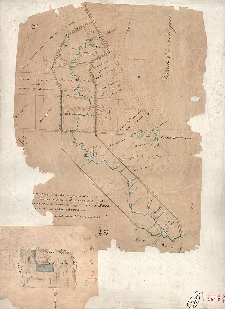
The current perspective of the Six Nations as to what constitutes the Haldimand Tract is found in the following link, which also helps put the land in context for those not familiar with the area - with cities such as Toronto and Hamilton in view. See here.
DeYo.
The Six Nations of the Grand River
The Grand River:
.jpg)
The Six Nations:
For a general understanding of the history of the Six Nations in Canada, see here for a broad overview.
For one single source, that provides a Six Nations chronology, and key information about the Six Nations claims, from the 17th Century to present day, there is no better source than the article here by Garry Horsnell.
It also has a reference section which is highly useful, and
for example provides online locations where one might obtain the following
source which includes the key documents relating to Six Nations history:
Charles C.M. Johnston, The Valley of the Six Nations: A
Collection of Documents on the Indian Lands of the Grand River, Toronto,
The Champlain Society, 1964.
The first Champlain Society printing, and the reprint of
1968 by the University of Toronto, are very difficult to obtain anywhere. However for the serious student of Six
Nations history, it is essential reading.

The above picture is by Mike Swanson, and shows the Grand River with some Six Nations accompanied by a member of Butler's Rangers or the Six Nations Indian Department (Young, Nelles, Huff, and Dochstader families) probably just after the Revolution, in 1784 when Chief Joseph Brant was looking for a suitable location for his people.
For more recent, largely Six Nations oriented, perspectives
see here, and here, and here.

The specific list of the 29 filed claims, both land and financial can be seen in the following two booklets. The first is found here. The second of the two, seen here, is the most comprehensive in relation to land claims.

The specific list of the 29 filed claims, both land and financial can be seen in the following two booklets. The first is found here. The second of the two, seen here, is the most comprehensive in relation to land claims.
Websites which primarily relate to the ongoing controversy between the Six Nations and the neighbouring townspeople, see Caledonia Wake Up Call here, Canadian Advocates for Charter Equality here, Caledonia Victims Project here.
The map below shows the contemporary boundaries of the Six Nations Reserve (No. 40). Most of the land is shown in green, but the block shown in Onondaga Township, Brant County to the west of Middleport, and the lands around A. Woodland Cultural Centre and B. Her Majesty's Chapel of the Mohawks is also part of Six Nations Territory.

Maps of the current Reserve which includes the newer purhased and exchanged acquisitions will be added later.
Some Terminology, Nomenclature and Miscellaneous Matters:
In writing this blog, I have faced the same task
that has at times "haunted" academic authors who feel the need to
justify everything - their career may depend on it.
I want to be respectful, but I also want to be
correct.
It is possible to use the term Native (an
equivalent to aboriginal) in contrast to native (as in a native born Canadian).
So big N, small N.
What about aboriginal. Should it be used for say
a Six Nations person? If so should it have a capital letter?
There was a time when "political
correctness" ran rampant, and everyone was petrified of being called a
"racist" so most decided that the best term to use for someone who
has status under the Indian Act is, "First Nations". This is still
used, but never really caught on except in a restricted way. Then there are the
Metis from Western Canada. They are generally placed in a separate category
with this term - which doesn't seem to be a problem.
I recall a couple of years ago when the Indian
newspapers debated about whether "Indian" was an acceptable word.
Most agreed that it was so deeply embedded in the history and culture that it
could stand - assuming of course that it is not being used in an insulting way
- another difficult subject. After all, there is an "Indian Act", and
"status" and "non- status" Indians.
Then there is the matter of the Six Nations. This
is a term seen everywhere including on welcome signs to the Reserve. There are
officially recognized groups such as "Six Nations Lands &
Resources". So it seems to be a term here to stay. What is out the door
though, unless speaking of a language category, is the word Iroquois. It is far
too general anyway. The name gaining prominence at Six Nations is
Haudenosaunee, pertaining to the Confederacy. The trouble is that if the
average person out there will end up tying their tongue on this. The public in
general would have little clue as to who you are speaking about. So if
Haudenosaunee ends up replacing Six Nations, I am guessing it will be in 20 or
more years - but I may well be wrong.
Well, to be fair, then what shall we call those
who are non - status people, those with no Indian ancestors or deep cultural
ties? Good luck in finding a "good" word to use in relation to
someone who has say an Indian grandparent, but was raised in say Toronto and
knows little of the culture and has never set foot on a Reserve. I know some in
this category. I don't have an answer or even a suggestion at this point.
So is the term "White" ok? The problem
with that is that it really emerged in relation to the history of slavery so
the word Black is ok for someone of African descent (I have had this debate
before with African - Americans and indeed, Black is a word used comfortably by
all parties). The problem these days is that Canadian society has changed so
much (well not in Caledonia, but in general). So there are people from the
Indian subcontinent, Asians (e.g., Chinese), Hispanics (with various admixtures
of say Spanish and Mayan), those from the Middle East, Greeks (who I guess are
White - but Mediterranean and rather different from say someone from Ireland).
The term European is semi ok, but translated directly would mean someone native
to Europe.
The term non-Native is in common usage, and I
really don't know about this one. I think the issue of terminology or
nomenclature is more clear in relation to the word being used now by some of
the outside supporters of the Six Nations - "settlers". That won't go
over at all well and probably should be dispensed with.
Have I forgot anything, perhaps something that
should be obvious, but since brain freeze has established itself ............
Actually, this topic is making me uncomfortable.
Good luck to us all in choosing the "right" word, and not causing
offence in the process. Maybe I think too much and ask too many questions. The
beauty of a blog is that I can babble on incessantly about this or that, but no
one really needs to listen to me or pay me much if any heed.
DeYo.
Subscribe to:
Posts (Atom)