The Editor of "Turtle Island News" (TIN), in the Editorial of 16 July 2014, appears to be speaking on behalf of the HCCC and HDI, and adds a statement that must be challenged! The Editorial is entitled, "Ontario is running from its responsibility to everyone". Here the evidence used by the Federal Government to label the Plank Road land claim as "not valid" is called, the "purported 1844 surrender". Furthermore, the Editor states that,
both levels of government have had eight years to resolve the issue and if they did have proof it would have shown up in 2006 instead of a disputed document that carries no names and they claim is signed by chiefs but can't prove chiefs actually signed the document.
That is not correct. I have seen the original copy of the document, and hold a copy of all of the chief's signatures at my other residence. I will in short order be ordering a photographic copy of the surrender, with all of the Chief's signatures, and will post it to the Internet.
The Editor has in a sense challenged me (or others making the same assertion) to put up or shut up. If there is relevant evidence, it clearly needs to be placed on public display. It would be very helpful if the Aboriginal Affairs Minister would honour us with his presence, and bring with him a certified copy of the surrender, and meet with both the Elected Council, and (separately) with the Hereditary Council to place the surrender on a table for all to see.
There seems to be a belief at Six Nations that there is nothing to support the assertion by myself and others that the Crown Patent to the DCE lands was granted after a legal surrender by the Six Nations Chiefs in Council. It is very frustrating to know that the documentation exists, to have seen it, even copied it, but still people deny its existence. So, I wonder if the following transcript will be adequate to convince the Editor of TIN that all along, I have been stating facts based on evidence freely available to all who wish to review it. Fair minded Six Nations people need to know that a highly pertinent written and signed surrender is out there, and can be seen on microfilm at a repository as close as Mohawk Street in Brantford. People need to know that the surrender was never contested by anyone at Six Nations (including those whose signatures are found on the surrender) until 150 or so years after the ancestors had accepted that the surrender (not to reserve this property) to the Crown was in the best interests of Six Nations people in 1844.
Looking back it is easy to try to second guess the Chiefs, or to challenge their decision, but that does them a serious disservice. After discussions among themselves, the Chiefs decided that they only needed Tuscarora Township and parts of three other Townships to meet the needs of their people. The Plank Road lands were deemed to be less important than for example the tier of lots in Onondaga Township between Chiefswood Road and Middleport where the Tuscarora already had a compact settlement. This they wanted to keep or "reserve", but on the south side of the River in Oneida Township the Lower Cayuga and Delaware people had begun migrating away from the Plank Road to nearby lots in Oneida Township west of Oneida Road and adjoining parts of Tuscarora Township.
Errors in Interpretation Abound: A problem that often surfaces in a misinterpretation of the historical reality here in the Grand River Tract, and assumptions and errors of attribution can create havoc, or at least require a lot of time and effort to address, in obtaining clarity in a subject that is, admittedly, complex. Some of these distortions are found even with academics, as seen in the rebuttal by Professor D. Johnston of the report submitted by Joan Holmes & Associates noted below. A detailed reading of sources such as that of C.M. Johnston noted below "should" reduce these false conclusions, but there always seems to be some way to re-interpret the data to fit some mold or other. Here follow some of the most commonly cited errors relating to the understanding of the history of the Six Nations in Ontario. It is necessary to obtain a clear grasp of these before offering the specific details of the 1844 surrender, and weaken efforts to question its validity.
Some Common Misconceptions: Unless someone has carefully studied the history of the settlement of the Grand River - Haldimand Tract from 1785, it would be easy to make false assumptions based on early published work which pertained to the League / Confederacy as it was constituted circa 1850. Before the works of Morgan, Parker, Hewitt and others there was simply no reliable source to provide information such as the names of the Hereditary Chiefs of the Confederacy. To project backwards from 1850 will take one into uncharted waters, and to project forward is not consistent with the written historical record.
It was NEVER the case at Six Nations that there were 50 Hereditary Chiefs of the Five Nations (N.B. Not Six Nations) as seen in "The Roll Call of the Chiefs" found in William N. Fenton, The Great Law and the Longhouse: A Political History of the Iroquois Confederacy, Norman OK, University of Oklahoma Press, 1998 (pp.193-194) . It was ALWAYS the case that at Six Nations Chiefs included both Assistant Chiefs (to each Hereditary Chief), Pine Tree Chiefs (such as Joseph Brant) and / or War Chiefs. All were Chiefs. On most occasions Principal Men were also accepted as Chiefs within the Longhouse at Six Nations. As I have noted in previous postings, there were also occasions when deeds were signed by all of the Principal Women. It is a very confusing and somewhat inconsistent picture - but it was what it was, and no one at the time questioned the inclusion of any of these individuals.
It is also the case that at the Grand River Chiefs also included representatives from the Tuscarora, Nanticoke, Tutelo, Delaware, Cherokee and other groups. Today of these groups, only the Tuscarora and Delaware are in sufficient numbers to be included separately on the official Six Nations Band List - the others amalgamated with these. For example, although the Latham family were Nanticoke, they resided with the Delaware and were enumerated as Delaware after about 1870. A Census of 1785 (see Charles M. Johnston, The Valley of the Six Nations: A Collection of Documents on the Indian Lands of the Grand River, Toronto, The Champlain Society, 1964, p.52) recorded:
Mohawks
Onondagas Council fire
Onondagas Bear Foot's party
Senecas
Onondagas from the West
Upper Cayugas
Upper Tootalies [Tutalo]
Oghquagas [Oneida]
Delaware Aaron's party
Oghquaga Joseph's party
Tuscaroras
Lower Cayugas
St. Regis [Onondaga]
Montours
Creeks & Cherokees
Lower Tootalies [Tutalo]
Delawares
Senecas from the West
Nanticokes
Some might question why there are so few Senecas among the Chiefs of the Grand River - considering their majority when all were residing in what is today Upstate New York. The simple answer is that the majority chose to stay in New York where they live today. An excellent resource for the titles existing and extinct at Six Nations, and which addresses the question as to who was considered a "Chief", is the book by Edward M. Chadwick, The People of the Longhouse, Toronto, Church of England Publishing, 1897 which can be found online here.
The first complete list of Six Nations Chiefs of the Grand River was recorded in 1815 by George Martin (Mohawk) for William Claus of the Indian Department. Seen here, there were then 22 Mohawk Chiefs (Principal and War). To make things more confusing, there were sometimes 4 Principal Chiefs (e.g., Bear Tribe) instead of the "traditional" 3 as seen here.
To expect standardization such as "50 Chiefs" simply does not accord with the data relating to the Six Nations of the Grand River at any point in their history. I have seen hundreds of deeds and surrenders signed either at the Indian Council House at Fort George, the Mohawk Village or, from about 1805 onwards, the Onondaga Council House. It is clear that the concept of "quorum" applied to some degree - there had to be an Onondaga present at the Onondaga Council House to open the ceremonies. However, whoever showed up that day, and who was eligible, signed whatever document was on the table. If there was perceived to be a need to have someone present who was not then present, the matter would be considered soon thereafter and the item signed again by all the Chiefs in Council on that day. The range of Chiefs, in terms of numbers who were authorized, and who signed a document ranged from 1 (one), Joseph Brant after he was given Power of Attorney in 1796, to 67 Chiefs in the 1840s. Few Six Nations questioned the legality of the documents, and if they did, the matter was redressed (e.g., the Brant Leases were converted to Crown Patents by the Chiefs in Council).
Land Inspection Returns: The lots along the Plank Road were no longer needed for the Reserve and so were given up for sale by the Crown and recorded in surrenders (descriptions of the lands the Chiefs wanted to reserve, and those they wished to dispense with). Individual Indians were permitted to retain any possessions they had, and at any time if these Six Nations members wished to sell their property and move to the new Reserve they were welcome to do so (emphatically and repeatedly stated by the Chiefs in Council as their wish, and accepted by the Indian Department and Government officials).
This process of migration to the west to be within the boundaries of what is today the Six Nations Reserve is shown in specific detail by the Land Inspection Returns of Oneida Township, lot by lot, with a survey of each property, submitted by James Kirkpatrick and Allan Park Brough on behalf of the Chief Superintendent of Indian Affairs, 11 March 1844 and updated 6 August 1846. Most Onondaga, Lower Cayuga and Delawares were about to sell or had already sold their improvements along the Plank Road to the person who was later granted a patent for the lot. The Six Nations members had largely moved (often less than a mile west) to the new Reserve by 1847 when location tickets were issued, and they could be assured of being included on the "Pay Lists" (known earlier as "Census for Presents", the earliest surviving record being that for 1856). For the Land Inspections see Library and Archives Canada (LAC), RG10, Indian Affairs Records, Vol. 729, e.g. pp.113-205. Some, however, did stay on the lands they had earlier cleared, and can be found in the Canadian Census of 1851 for Oneida Township outside the Reserve, however the Census records show that by 1861 almost all had moved to land within the present day Reserve boundaries.
The specific reference for the 1844 Surrender, and Details of the Surrender: As noted in earlier postings, this is found at Library and Archives Canada (LAC), RG10, Indian Affairs Records, Vol. 144, pp. 83269-83279. This document can be found on microfilm reel C-1149 at the LAC, the Archives of Ontario, or the Woodland Indian Cultural Center (the former Mohawk Institute) on the Reserve near Brantford. Years ago I made a copy of the document. I was particularly interested in the signatures of the chiefs who were present - since that was the subject of my research at the time. Little did I realize 30 years ago how important these pages would be so many years later.
To repeat, somehow this document is being ignored, or the HCCC are pretending it does not exist or that there is supposedly some other sort of anomaly in the deed that no one ever noticed until 1987 when a series of land claims (29) were submitted by the forerunner to the Six Nations Land and Resources Department. The claim for the return of the land was withdrawn in 1995 by the Lands and Resources Department (administered by the Six Nations Elected Council the detested rivals of the HCCC, and considered illegitimate by the latter). The Federal Government and the researchers and legal team for the Elected Council know that the remaining contested claim is about money not land. See here for the Elected Council's Land and Resources Department's list of land claims and details of what they expect from the Federal Government.
Returning to the significance of the 1844 surrender, I also have census documents from the 1840s indicating the tribal affiliation of each Chief and will also include this information once I can access my "secondary" records. I say secondary because the records to which I had access at the Haldimand County Museum and Archives, and stored in about 10 archival boxes, are no where to be found. They contained deeds and surrenders from the late 1600s to the mid 1800s. According to the former curator, they were last seen in the possession of "two women from Ohsweken" and between that time and the arrival of the new curator in 2009, and when I arrived at the Museum to access the data, the records "disappeared". I did, however, have duplicate copies of some of the records with signatures which I keep at a storage facility in the United States. So in the meanwhile, I will list here are the names, in alphabetical order, of the Chiefs who in Council at the Onondaga Council House, signed the document. This information is found in the report of Joan Holmes submitted to Justice Harrison Arrell in the Injunction sought by the Corporation of the City of Brantford in 2009 (see here) against the HDI and other Six Nations members. Be sure to see both parts of her report. Her team examined the same documents that I and other researchers, and Justices of the Ontario Supreme Court accepted as evidence, and all came to the same conclusion - there is no valid Plank Road land claim.
The description of the property on which DCE sits is repeated in subsequent meetings as with each change until 1848, when all was finalized, the land to be reserved was described so that all knew exactly what area was being kept or reserved, and what was being surrendered. On more than one occasion they said that they wished to reserve only that part of Oneida Township west of the tier of lots along the Plank Road. DCE is among the tier of lots on the west side of the Plank Road and was hence surrendered. For example the Council minutes of the 18 September 1845 meeting again stated that the Chiefs (66 were in attendance on this occasion) were reserving Tuscarora Township and also reserving the part of Oneida Township west of the tier of lots bordering the Plank Road - in other words the part today between Oneida Road and Tuscarora Township - and ratifying what was done previously.
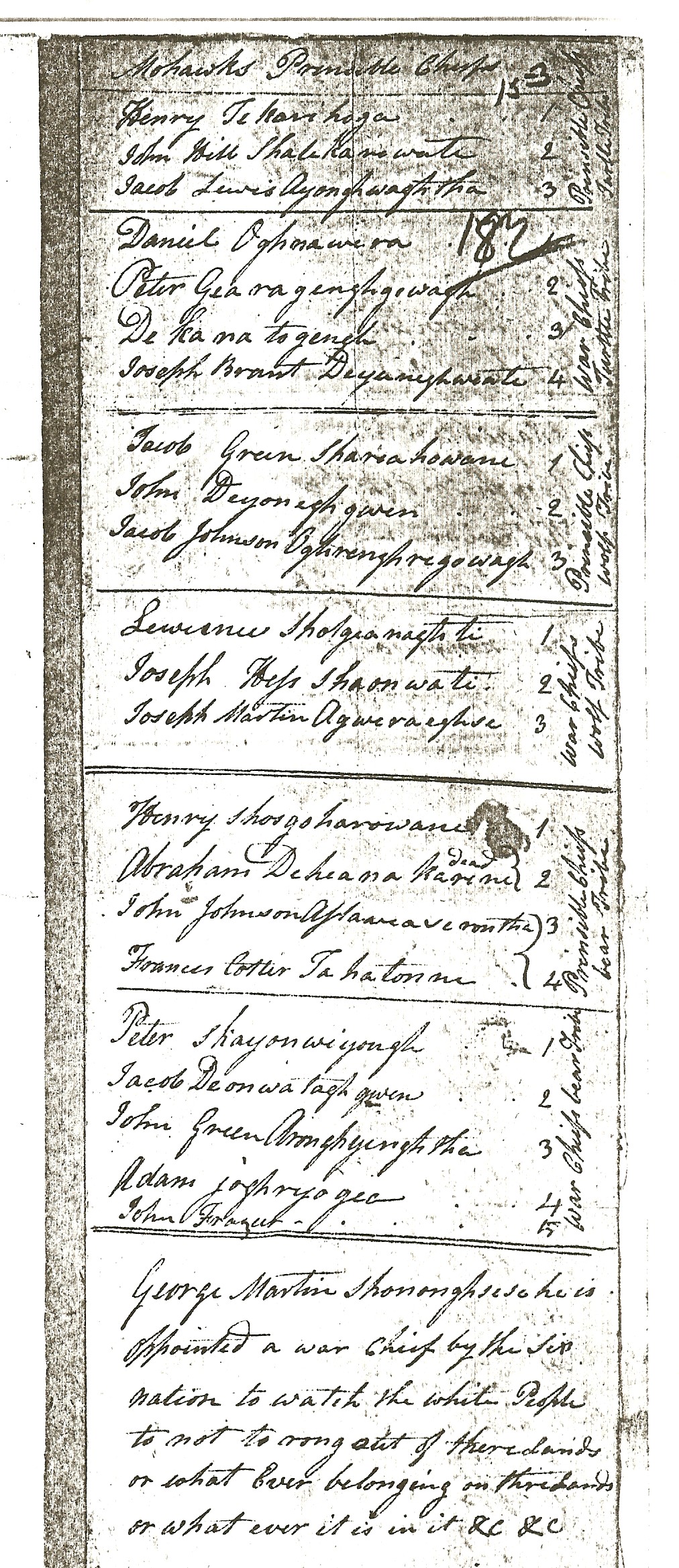
Surrender of Plank Road Lands - Numbers of Chiefs from Each Nation: We know the numbers of chiefs from each tribe / nation based on the roll call noted on page 83278 of the aforementioned document dated 18 December 1844. The specifics are as follows and can be seen on page 44 of Garry Horsnell's transcription here:
In attendance at the Council meeting were David Thorburn, Commissioner, James Winniett Esq., L.S.A. and 47 Chiefs. These 47 included:
Upper and Lower Mohawks = 13
Cayugas = 9
Tuscaroras = 7
Onondagas = 6
Oneidas = 4
Delawares = 4
Senecas = 2
Nanticokes = 2
----------
47 Chiefs
The list of the 47 Chiefs Who Signed the Surrender: To show that the identity of these Chiefs is known, I have added in the tribal / nation affiliations of each from memory. Spelling is difficult to interpret as is true of all deeds with Indian names since even with Native interpreters doing the spelling, there was not absolute consistency to the last letter - but all can be identified (many use European names). I will later add in tribal / nation of the rest of the Chiefs below using the "Census for Presents", "Agricultural Census of 1843", and other relevant documents which I have in storage elsewhere:
1) Chief Buck (opened council) - Firekeeper, Onondaga
2) Chief Henry Brant (speaker, presenter) - Head Chief, Upper Mohawk
3) Jacob Martin (interpreter) - Lower Mohawk
4) George Anthony - Head Chief, Delaware
5) Aghsigwaresere - Mohawk
6) Aghakaris
7) John Bull - Delaware
8) Isaac Burning - Moses Walker Mohawks, Upper Mohawk
9) Nicholas Burning - Moses Walker Mohawks, Upper Mohawk
10) Seneca John - Head Chief, Nikarondasah Seneca
11) Lawrence David - Upper Mohawk
12) Peter Deer - Upper Mohawk
13) Cornelius Douglas - Tuscarora
14) Joseph Doxtator - Mohawk
15) Jacob Fish - Upper Cayuga
16) Peter Fishcarrier - Lower Cayuga
17) Peter Green - Head Chief, Auquaga (Oneida)
18) Joseph Hess - Upper Mohawk
19) Samson Hess - Upper Mohawk
20) Peter Hill
21) William John - Upper Mohawk
22) Elijah Johnson - Lower Mohawk
23) John Smoke Johnson - Lower Mohawk
24) William Johnson - Lower Mohawk
25) Kanonhgeritawi
26) Kanyakaroton
27) Kanorisayon
28) Patrick Latham - Head Chief, Old Nanticoke Family
29) Isaac Lewis - Upper Mohawk
30) Abraham Maracle - Head Chief, Bay of Quinte Mohawks
31) Joseph Montour - Head Chief, Lower Cayuga
32) John Obediah - Head Chief, Tuscarora
33) Joseph Osegiraga
34) Ojakehete - Lower Cayuga
35) Ojinonyata
36) Onakaronton
37) Onesconren
38) Noah Powless - Upper Mohawk
39) Shagokaryas
40) Skanawate
41) Peter Smith - Mohawk
42) Tayekanskhot
43) Tegharaniraryak
44) Tewahinnote
45) Teyonhohisin
46) Moses Walker - Head Chief, Moses Walker Mohawks (Upper Mohawk)
47) John Young - St. Regis Onondagas
It is many times more difficult to accurately identify Six Nations who at the time are recorded under only their Haudenosaunee name. There are dialect differences within languages, and there are great similarities between the Six Nations languages such that a phonetic translation (good or bad) is hard to link up to names in for example the Census for Presents of 1856. It is "doable" but, it would take someone who is more familiar with Haudenosaunee languages than myself to do this job with any degree of confidence. In other words there are limitations in individual identification of the Hauenosaunee names of for example Lower Cayugas in the 18 December 1844 document. All of the Lower Cayuga do have a White pre and surname at this time (e.g., Young Warner, Henry Young(chief), Jacob Silversmith). The latter names are used somewhat haphazardly - some Indian Department officials would choose to use the White names, some not. Most of the merchants in the Caledonia area (whose customers tended to be Lower Cayuga and Onondaga) listed the White names, and often as well the Haudenosaunee name, in their account books. There are good economic reasons to have as much information as possible with the individual accounts, since often the Indian Department, for one reason or another, was often left to pick up the tab of delinquent accounts - and merchants needed to prove the specific identity of their customer.
The Mohawks, most of whom only use a White name for official purposes (e.g., signing a surrender, being listed on the Census Records ("for Presents") of the 1850s and 1860s, then the Band Lists which begin in the 1870s). The Mohawks, in particular, are parsed into various "parties" or factions, but were frequently lumped together under either Lower or Upper Mohawk, and sometimes listed by their specific grouping such as "Moses Walker Mohawks", as is the case with the 1856 Census Returns (LAC, RG10, Vol. 223, pp.132530j-132530ff).
Here follows scans of photocopies of the rather poor microfilm copies from the above noted microfilm reel. Clearly photographic copies of the original documents will be needed eventually, but for the present, these documents clearly show that on 18 December 1844 the Chiefs in Council did sign the document agreeing to the surrender of the lands from the Plank Road to what is today Oneida Road and the boundary of the present day Reserve. Only the pages stamped 83275 (first two pages below) and 83276 (third and forth pages below) are included here since the goal was to show all of the signatures.


.jpg)
The above list will suffice until I can order copies of the original documents (not microfilm copies) from LAC.
The point is, however, that clearly the Editor's assertion does not hold water.
DeYo.
This is interesting - I'm a Latham - we've been doing family research and have found some stuff that would indicate that they were Nanticokes, although to this day family members are registered as Delaware. Would you be willing to share copies of any original documents you have found?
ReplyDeleteThis comment has been removed by the author.
DeleteThis comment has been removed by the author.
DeleteHi, there were the "Old Nanticokes" and the "New Nanticokes". It appears that all Lathams descend from one Patrick Latham who during the 1850s lived in what is today Cayuga - he had a very large family. Eventually the Nanticokes (and groups such as the Tutelo) were all recorded as Delawares - but that was all about consolidation for administrative convenience.
DeleteBy 1860 most of the Lathams moved to the Delaware settlements at Willow Grove along Highway 6, and soon after to Smoothtown.
As I recall Patrick and family are found in the 1851 and 1861 Canadian Census for Haldimand County - microfilm copies of which are widely available, and indexed digital images on Ancestry.com or the free www.familysearch.com site.
Patrick Latham was “Old Nanticoke” (1856 Census Returns (LAC, RG10, Vol. 223, pp.132530j-132530ff).
For what it is worth, I recall that there was an administration for the estate of a Latham (James?) in 1794 with his possessions being inventoried with the proceedings taking place in the Mohawk Village. It was not noted whether this Latham was White or Indian. DY.
Thanks for your response...you sure know your Latham's! With the exception of the Willow Grove settlement, we have come across most of that. Our Latham's ended up settling in the Dunnville area. There is a long saga of how the Cayuga land was lost (or taken) depending on how you read it. You may find it interesting.... http://collectionscanada.gc.ca/pam_archives/index.php?fuseaction=genitem.displayEcopies&lang=eng&rec_nbr=2081015&title=SIX%20NATIONS%20RESERVE%20-%20CLAIM%20BY%20THE%20FAMILY%20OF%20JAMES%20LATHAM%20TO%20BE%20ON%20THE%20PAYLIST%20AND%20A%20CLAIM%20TO%20BE%20PAID%20FOR%20IMPROVEMENTS%20ON%20LOTS%2030%20AND%2031,%20CON%201,%20NORTH%20CAYUGA%20TOWNSHIP.&ecopy=e007588833
DeleteHello John,
DeleteThanks for the reference. Will study the info in due course. Back at that time there was at least one very unscrupulous individual who was not averse to using whatever means to cheat White or Indian folk out of land in North Cayuga Township (I don't recall his name, but I have it in my records somewhere).
After the surrender of 1841 it was repeatedly noted that no Indian need more to the consolidated Reserve. However, if at a later date they wished to sell their lands say at the Oxbow, they would be able to move to the Rez and would be allotted land. However the difficulty the Lathams had in getting on the Paylist, and the fact that they were not technically Six Nations individuals (something that was an issue for some of the Hereditary Chiefs as reflected in the Council Minutes) - Stockbridge (Mahaican) individuals being considered "foreign Indians" for example, just complicated things.
Were you able to find out anything about the generations before Patrick Latham, and where they lived in say the 1820s? DY.
If memory serves, the name of the shady character noted above was Marcus Blair. DY.
DeleteHi. We think that Patrick's father could have been James Latham - the James that you refer to in one of your posts above. We found census records that say Patrick was born in 1795. James' estate was being handled by John Young Jr. at Mohawk Village in 1797. Patrick also had a son named James, which would make sense. The younger James (Patrick's son) is the one for whom the "Collections Canada" file I directed you to earlier was initiated. When the younger James (Patrick's son) died, the Indian Agent said that his wife was not registered as an Indian, so evicted her from the Cayuga land after a long battle. We have discovered, however, that she actually was an Oneida. The Cayuga crown attorney, who owned land next door, bought the property at auction to expand his holdings. After she was evicted and finally left the property, they then "relisted" her as an Indian. It all seems very convenient, looking back on it now, but who knows for sure!? My great-grandfather (John) was a young child when they were evicted.
DeleteAs you note, the original James Latham had an estate that was handled at Mohawk Village. We wondered what his estate could consist of so tried to do some further digging - we found that a James Latham owned a few hundred acres of land on the Chippawa Creek near what is now Attercliffe (Township of Wainfleet). That land was squatted on and cleared by settlers known as the "Sensabaughs", and there is now a "Sensabaugh Cemetery" on part of that land. That was curious to us, because our grandparents and great-grandparents knew and were friends with Sensabaughs. Still trying to piece it all together, it is quite interesting the more you look into it!